


Bobo Voting District, Coahoma County, Mississippi
About
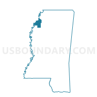
Outline

Summary
| Unique Area Identifier | 605241 |
| Name | Bobo Voting District |
| County | Coahoma County |
| State | Mississippi |
| Area (square miles) | 35.57 |
| Land Area (square miles) | 35.56 |
| Water Area (square miles) | 0.01 |
| % of Land Area | 99.98 |
| % of Water Area | 0.02 |
| Latitude of the Internal Point | 34.13077900 |
| Longtitude of the Internal Point | -90.65814910 |
Maps


Graphs
Select a template below for downloading or customizing gragh for Bobo Voting District, Coahoma County, Mississippi


Neighbors
Neighoring Voting District (by Name) Neighboring Voting District on the Map
- Cagle Crossing Voting District, Coahoma County, MS
- Clarksdale 4-2 Voting District, Coahoma County, MS
- Clarksdale 5-4 Voting District, Coahoma County, MS
- Duncan/Alligator Voting District, Bolivar County, MS
- Rena Lara Voting District, Coahoma County, MS
- Roundaway Voting District, Coahoma County, MS
Top 10 Neighboring County Subdivision (by Population) Neighboring County Subdivision on the Map
- District 3, Bolivar County, MS (5,952)
- District 5, Coahoma County, MS (4,902)
- District 4, Coahoma County, MS (4,633)
Top 10 Neighboring Unified School District (by Population) Neighboring Unified School District on the Map
Top 10 Neighboring State Legislative District Lower Chamber (by Population) Neighboring State Legislative District Lower Chamber on the Map
- State House District 25, MS (29,000)
- State House District 30, MS (19,921)
- State House District 26, MS (18,014)
Top 10 Neighboring State Legislative District Upper Chamber (by Population) Neighboring State Legislative District Upper Chamber on the Map
Top 10 Neighboring 111th Congressional District (by Population) Neighboring 111th Congressional District on the Map
Top 10 Neighboring Census Tract (by Population) Neighboring Census Tract on the Map
- Census Tract 9501, Bolivar County, MS (3,805)
- Census Tract 9503, Coahoma County, MS (3,267)
- Census Tract 9502, Coahoma County, MS (2,672)